Bankstown airport officials have denied that the airport has been expanded at any
time between 1996 and 2000. There is clear evidence to the
contrary.
Coming up below are sections from two aerial photographs of
Bankstown Airport. Both were derived from Central Mapping Authority
Photos. Nothing has been altered materially - see below for full
details.
How many differences did you spot ? Fill this in, then test yourself against the
answers in the Legend section (later you can press the submit
button -bottom of page- to email your estimates and comments).
How are runways numbered ? Let's take 11C/29C as an example. The C is for CENTER (at KSA, you have R and L for Right and Left).
The 11 is tens of degrees from due North. So its 110 degrees
compass heading, or 20 degress South of due East. A plane
heading in this direction is said to be using 11C. One using the
same runway in the opposite direction is on a heading of 110+180
or 290 degress, hence the 29 in 29C.
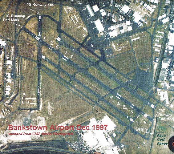
1 - 1997 11C Runway Threshold is permanently displaced
some 160 m in from the Runway End Mark, an exceptional
configuration (compare with other runways, and see below). This is
approximately 80 m further along than where it was in 1996.
The threshold is marked by a 1.2 m wide line extending the full
width of the runway. Six (6) meters inside this line, there are
then a series of 30 m long piano-key stripes, which appear as light
grey rectangles in this photo due to their close spacing (there
should be two sets of 8 stripes, each 1.5 m wide and 1.5 m apart
with a central 3 m gap). The runway end mark (if not coincident
with the threshold), is a 1.2 m wide line extending the full width
of the runway.
1' - 1996 11C Runway Threshold.
If your monitor has sufficient resolution, you should be able to
see the "scar" where the old threshold piano-keys have been painted
over.
How can they denythe
extension ? The length it defines has increased by 80 m ! That's
length extension (difference) No. 1.
Second Length Extension
2 - 1997 11C
Touchdown Zone Marking - A 30 m by 3 m mark near edge of
runway that is supposed to be 150 m inside the Runway
Threshold.
2'- 1996 11C Touchdown Zone
Marking - Scar of painted over marking, approx 80 m inside
latest mark. That's length extension (difference) No. 2.
Third Extension
1997 3 - 11C
Runway Fixed Distance Mark - A 45 m by 6 m mark near edge of
runway that is supposed to be 300 m inside the Runway
Threshold.
3' - 1996 11C Runway Fixed Distance
Mark - Scar of painted over marking, approx 80 m inside
latest mark (3). That's length extension (difference) No.
3.
Fourth Extension
4' - 1996 29C Runway Fixed Distance
Mark - Scar of painted over marking, approx 80 m inside
latest mark. That's length extension (difference) No. 4.
4 - 1997 29C Runway Fixed Distance
Mark(4)
Fifth Extension
5' - 1996 29C Touchdown Zone
Marking - Scar of painted over marking, approx 80 m inside
latest mark (5).That's length extension (difference) No.
5.
5 - 1997 29C Touchdown Zone
Marking.(5)
Sixth Extension
6' - 1996 29C Runway Threshold.
The old scar is approximately 80 m inside the new one (6).That's
length extension (difference) No. 6.
6 - 1997 29C Runway
Threshold.(6).
Seventh Extension
7 - 1997 29C Runway End Mark -
This is now at the end of the R2 taxiway - no longer just at the
end of the threshold. That's length extension (difference) No.
7.
So we now have a permanently displaced
threshold. Why ?
The distance from the threshold to the end mark is about 60 m.
That just happens to be the length that a Runway End Safety Area
(RESA ) should be if Regular Public Transports
are not using the runway [RPA98, p7-42]. This also matches the ERSA
published differences between TORA and TODA .
If you have Regular Public Transports (RPT), you are supposed to
have 90 meters of RESA. But folks, there's a problem here. There's
a drain, about 25 meters past the runway end mark (only 15 m if you
believe airport managers report to
Council) - such obstacles are the natural enemy of runway
safety areas (see later definitions ).
But don't worry. Just tell the locals you're fixing a safety
issue, and quietly extend the runway strips a little bit more so
that they can have 737's and other regular public transports
blundering over their silly little heads all night and day.
Do you think there's been extensions ? How can BAL say
there's been no extensions ?
We've counted 7 differences in vital runway lengths so
far...
In case you think that some of them aren't very big changes,
11/29C has now increased from having an Aerodrome
Facility Reference Code Number of 2 to 3 (for the 11C/29C
runway) - and that means lots bigger
planes .
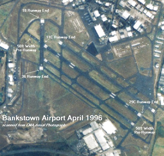
8 - 1996 11C Pre Runway - The
11C runway end had a 50% width pre-runway
extending approximately 220 meters from the 1996 end to the W2
taxiway. See definition later for what a pre-runway is - it's not part of the runway and
does not add to the runway length useable in aircraft weight-limit
take-off calculations.
The pre-runway has been clearly increased in width, formed into
runway, and is now included in the TORA and TODA lengths.
Aerial photographs don't show what specifications this runway
contstruction was built to, but there's probably differences in
there too. That's size extension (difference) No. 8.
Ninth Extension
9 - 29C Pre Runway - The 29C
runway end had a 50 % width pre-runway extending approximately 150
m from the S2 taxiway intersection to the R2 taxiway (and new end
mark). This pre-runway has been clearly increased in width, formed
into runway, and is now included in the TORA and TODA lengths. It's probably also now
included in the current RESA specification. That's size
extension (difference) No. 9.
Tenth Extension
10 - Runway 18/36 has been
sealed for approximately 400 metres on the southern (36) end, but
is clearly narrower than the top section. This has doubled its
size.That's length extension (difference) No. 10.
Eleventh Extension
11 Theshold - The runway threshold is now 230 m further south.
That's length extension (difference) No. 11.
Twelfth Extension
12 - 36 End Mark - The 36
runway end mark is 330 m south of the 1996 location. Note that this
now makes this threshold a permanently displaced one - possibly due
to obstacles like the aviation museum or other buildings planned
for the south west corner. That's length extension (difference)
No. 12.
The definitions herein are drawn mostly from the Airservices
Australia "Rules and Practices for Aerodromes", as published in
July 1998. They are provided in the public interest of informing
the Bankstown community of aviation terms, so that the public may
better ascertain the truth or otherwise of claims made regarding
the airport development. Australia uses ICAO standards primarily,
and these are often similar to USA FAA standards, and hence this
information may be useful to airport communities elsewhere in the
world.
While great care has been taken in checking the accuracy of this
material, it is not intended and is not
suitable for use for operational purposes, nor in training
of pilots, airport planners, administrators or other airport staff.
Any person requiring information for those purposes should consult
the latest and official documentation.
The Critical Aeroplane-"The critical aeroplane is
a conceptual aeroplane whose characteristics are a composite of the
most critical elements of all the aeroplanes that the facility is
intended to service. For example, in the design of a runway the
critical characteristic determining runway width may derive from a
different actual aeroplane than the critical characteristic
determining clearance to the parallel taxiway...
It is the aerodrome operators' responsibility to determine the
critical aeroplane for each aerodrome facility. This should be done
in close consultation with users (airlines etc.,), and the
CAA"[RPA1998,p7-2]
If the airport managers have properly
discharged these responsibilities, it should be a simple matter to
describe the critical aeroplanes for the runways and taxiways. Why
not ring them and ask for an answer ?
Is the proper answer to this question, a 737-300 ?
Should we ask, who defines the areas ? Is it by some order
issued under a section of the act or regulations governed by it ?
Instrument
Runways - "A runway may also be referred to as being either
an instrument runway, or a non-instrument runway. A non-instrument
runway is intended only for the operation of aeroplanes using VFR
(Visual Flight Rules) procedures".[RPA98,p7-11]
Instrument runways are further classified into two types,
non-precision approach runways, suitable for moderately poor
weather, and precision approach runways for very poor
weather[RPA98,p7-12].
Non-Precision
Approach Runway - an instrument runway equipped with visual
aids, and a radio aid providing at least directional guidance
adequate for a straight-in approach.
Non-Precision Approach Runways are typically served by visual
aids such as T-VASIS, runway markings, and runway lights, and radio
aids such as an NDB, VOR and DME. As from July 1998, Global
Positioning System (GPS) aids were added to the list, and
concessions made to allow their use on runways of less strip width
than previously allowed for NPA runways.
Precision
Approach Runway - there are three categories, for various
types of aircraft. Essentially, precision approach provides height
as well as directional guidance with the strictest category (IIIC)
supporting landing in zero visibility conditions.
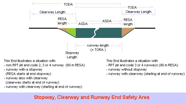
Runway
Strips - "A runway and any associated Stopways are to be centrally located
within a runway strip. This is an area provided both to reduce the
risk of damage to aircraft running off a runway and also to provide
an obstacle-free airspace for aircraft flying over the area during
take-off or landing operations. The runway strip, therefore,
comprises a graded and obstacle free area specially prepared to
minimize damage to aircraft should it run off the runway, and also
to allow aircraft to fly over the area safely. The whole width of
this runway strip is a graded area."[RPA98,p7-32]
"The runway strip is to extend beyond the end of the runway or
Stopway, if provided, for a
distance of 30 m for code 1 runways and 60 m for code 2, 3 and 4
runways." [RPA98,p7-33]
Has 11/29C, since 1996, become a code 3 runway
- does the drain mean the strip length does not meet this
requirement ? . See if you think the drain is closer than 30 m since the
1996 work.
Runway
Threshold - "the point on the ground from which the landing
distance available to an airplane is measured. It's position on the
ground is basically determined by the airspace requirements of the
airplane and in particular the requirement for a landing aeroplane
to be able to fly down an approach path that is completely free of
obstacles.
For a new runway, the beginning of the runway is normally made
to coincide with the threshold. However, in exceptional cases where
this would result in an inadequate runway length for takeoff (in
the same direction), the beginning of the runway may need to be
located prior to the threshold, as shown in the following diagrams"
[RPA89,p7-13]. The Aerial photos indicate Bankstown is exceptional
- they're really squeezing things in.
The threshold is marked by a 1.2 m wide line extending the full
width of the runway. Six (6) meters inside this line, there are
then a series of 30 m long piano-key stripes, which appear as light
grey rectangles in this photo due to their close spacing (there
should be two sets of 8 stripes, each 1.5 m wide and 1.5 m apart
with a central 3 m gap).
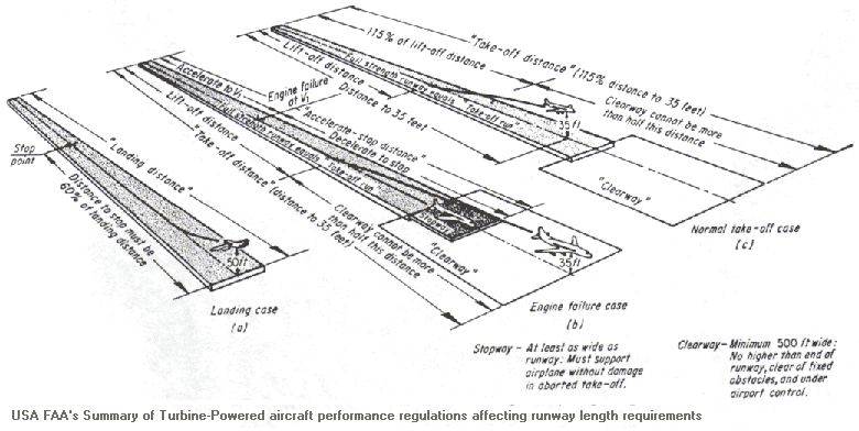
Click here for a takeoff
perspective diagram (47K) illustrating runway features to USA
FAA standards. Even though there are differences, this may help
your understanding of some of the terms (click here for more on FAA terms )
Runway End Safety
Area (RESA) - "areas of ground at each end of a runway,
symmetrical about the extended runway center line, and abutting the
end of the runway, or Stopway
if provided. RESAs are provided to reduce the risk of damage to a
landing aeroplane which touches down before the threshold, or to an
aeroplane overrunning the end of a runway either during landing or
in an aborted take-off." [RPA98,p7-38].
"A RESA should be provided at each end of the runway, or Stopway if provided, for as
great a distance as is practicable."
"The minimum length of the RESA is to be 90 m where the
associated runway is suitable for aircraft with a code number of 3
or 4" (i.e. Bankstown's 11/29C) "and is used by regular
public transport jet aeroplanes" (also at Bankstown)
[RPA98,p7-38].
"In other cases, the minimum RESA length is automatically
provided for by the requirement for the runway strip to extend
beyond the end of a runway... Where provision of a RESA is not
feasible due to terrain constraints or obstracles, consideration
should be given to reducing some of the declared distances in order
to meet the RESA requirements".[RPA98,p7-38]. The RESA width should
be twice the width of the runway.
As noted above, 11C/29C's strip does not provide
the necessary 60 m graded area at the end. So should the drain's
presence at Bankstown have prevented the increased declared runway
lengths?
USA's FAA standards require much longer RESA lengths. For
precision instrument operation with small aircraft, 180 m is
required, and for large aircraft in all design groups 300 m is
needed [Horonjeff83, p395]. So don't think the Australian Standard
is maybe too fussy and that airport managers could be excused for
ignoring it.
Clearway- "an obstruction free rectangular
plane, extending from the end of a runway, over which an aeroplane
taking off may make a portion of its initial climb to 35 feet (10.7
m) above the ground at the end of the Clearway.
It is used to increase the take-off distance available (TODA) without increasing the length of
the runway proper. Thus a Clearway is not prepared for the surface
movement of aircraft, but only to be cleared of upstanding
obstacles to permit safe overflying" [RPA98, p7-39]. Looks like
drains can be in Clearways.
"The Clearway commences at the end of the take-off run available
(TORA ). A Clearway overlies
part of the runway strip (e.g. that part not paved with runway),
including any Stopway, if
provided, and may overlap part or all of the runway safety
areas.
The declared length of the Clearway is not to exceed half the
length of the TORA, i.e. the
Clearway will be equal to or less than half the runway length."
[RPA98, p7-39]
Stopway,- "a rectangular area of ground,
originating at the end of a runway, on which an aeroplane may be
stopped in the case of an aborted take-off. A Stopway may be used
to achieve the financial savings associated with lower strength
pavement and the absence of runway marking and lighting.
A Stopway is to finish at least 60 m before the end of the
runway strip" [RPA98, p7-40]
Note that 11C/29C at Bankstown does not even 15 m between the
runway eastern (29C)end and the strip end! But when the drain is
filled in, it will.
"In considering the length required for a Stopway, it should be
noted that this length is used by pilots as part of the
calculations to determine the payload that can be uplifted from the
runway"
"A Stopway is to have the same width as the runway with which it
is associated". So, prior to 1996, the pre-runways should not have
been called Stopways - weren't they too narrow ?
Pre-Runways- "the pre-runway marking is to be
used where an area exceeding 60 m in length before the runway has a
sealed, concrete or asphalt surface, and is not suitable for normal
use by aircraft. This marking is to consist of yellow chevrons
space 30 m apart"
The area marked by the pre-runway end marking will not normally
be used for landing or take-off. If this area is declared as a Stopway, it may only be used by
an aircraft in the case of an abandoned take-off or from the other
direction under emergency conditions" [RPA98, p11-4]
Runway
Width- " The appropriate runway width requirement may be
determine by cross-reference to the Table of Width of Runways using
the 'critical' aeroplane reference code. The runway width standards
specified in the table are to be used for the construction of a new
runway or the upgrading of an existing runway.
"Aerodrome operators are advised that some aeroplanes may be
permitted to operate from runways with width not in accordance with
the Table of Width of Runways above under any one of the following
circumstances:
An aeroplane may be operated from a runway one width less than
that specified in the Table of Width of Runways above provided
[RPA98,p7-21]:
it was manufactured in the USA and the Federal Aviation
Administration aircraft design group permits a runway width
narrower than provided by the Table of Width of Runways; or
it has an aeroplane reference field length (AFRL) less than
1500 m and all flight manual crosswind limits are reduced by
50%.
(omitted)
The Authority has conducted runway width testing of an
aeroplane and approved its operations at narrower runways
(omitted)
And in fact [RPA98, p7-30] 737-300's are certificated by the CAA
to operate on 30 m wide runways (as if they were 3C category, like
BAe 146's and Gulfstream IV's). They operate at Launceston,
Maroochydore, and Hamilton Island all of which have only 30 m wide
runways.
Runway
Lengths - "The length of a runway to be provided at an
aerodrome is to be determined by the aerodrome operator. It should
be adequate to meet the operational requirements of the crticial
aeroplane, at the desired Maximum Take-Off Mass (MTOM) for which
the runway is intended. The operational requirements of aeroplanes
are normally determined by airlines or aeroplane operators, within
the aeroplane mass and performance limitations set by CAA".
Because of the "should be" terminology, this is
only a recommendation. The runway length does not have to suit the
Maximum possible take-off weight for an aircraft. An airport
operator has the freedom to allow aircraft to operate, for
instance, at weights lower than their maximum (if he/she were
really concerned that the runways could take only 50 tons).
Accordingly, the runway length should be determined in close
consultation with the airlines and other aeroplane operators that
the aerodrome operator wishes the aerodrome to accomodate, and the
CAA, so that the desired maximum capacity may be obtained at the
lowest cost.
When arriving at the length of the runway required, the
aeroplane operator will utilise data provided by the aeroplane
manufacturer and certified by CAA. These data cover the following
considerations:
the maximum take-off mass of the critical aeroplane
the maximum permissible landing mass of the critical
aeroplane
the climb performance, and braking performance of the critical
aeroplane
the longitudinal slope of the runway
the air temperature and density based on the location and
elevation of the aerodrome
the wind velocity
the runway surface condition: wet or dry.
Might we wonder who BAL have been consulting with in recent
times ?
Declared
Runway Lengths - There are standard aviation terms to report
runway lengths that are critical to aircraft performance - in
determining the size and range of aircraft that can operate on a
runway. There are four declared distances (CASA definitions in
italics, taken from Publishing Aerodrome information and reporting
changes, a Civil Aviation Advisory Publication, CAAP 89O-1(1), May
1997):
TORA- takeoff run available - "the length of
runway declared available and suitable for the ground run of an
aircraft on taking off. It will normally be the full length of the
runway. Neither Stopway nor
Clearway are involved."
[CAA97, CAAP 89)-1(1), p17] [In most cases, this corresponds to the
physical length of the runway pavement]
TODA - takeoff distance available - "defined at
the distance available to an aeroplane for completion of its
ground-run, lift-off and initial climb to 35 feet. It will normally
be the full length of the runway plus the length of any Clearway. Where there is no
designated Clearway, the part of the runway strip between the end
of the runway and the runway strip end is included as part of the
TODA. This Australian practice has been registered with ICAO. Any
Stopway is not involved."
[CAA97, CAAP 89)-1(1), p17]
From Bob Tait's Aviation Theory School, VFT
Study Guide p1.2.4, "the length of take-off run declared available,
plus the length of any Clearway available. TORA plus length of any remaining runway
and/or Clearway beyond the far end of the TORA. The take off
distance allows for the aircraft to remain on the ground to the end
of the TORA, and then climb to 50 ft (propeller aircraft) or 35 ft
(jets). The Clearway surface may be totally unsuitable for aircraft
to run over - it is provided for the unobstructued climb to 50 ft
It does not consider transient obstacles such as trucks or buses
which may be passing by.
ASDA -
accelerate-stop-distance-available - "the length of the
take-off run available plus the length of any Stopway. Any Clearwayis not involved." The
Stopway is available for the deceleration of an airplane aborting a
takeoff
LDA - landing distance available - "The length
of the runway available for the ground run of a landing aeroplane.
The LDA commences at the runway threshold. Neither Stopway nor Clearway are involved."
Landing distances for aircraft are usually much smaller than
take-off (no allowance need be made for aborted take-offs or engine
failures).
Enroute Supplement
Australia (ERSA) - An Aeronautical Information Publication
(AIP) published by Airservices Australia and widely distributed to
pilots and airlines. It contains "aerodrome information of a
lasting character, in two separate sections. The Facilities section
sets out all the facilities available at an aerodrome. The Runway
Distances Supplement Section sets out in detail runway declared
distances information... The ERSA is updated quarterly" [CAAP
89O-1(1)97,p3]
While trying to argue that no runway extensions had occurred and
that ERSA distances were not evidence of these, A BAL manager once
claimed "The En Route Supplement (ERSA) reports the effective
operational lengths available at time to time and does not report
the actual length of the strips". Don't buy it. The ERSA changes
are of a lasting character. See NOTAM definition for the temporary
changes.
Additionally, the 1996 and 1997 FAC Annual Reports provide a
listing of airport data (Appendix 11 of each). In 1996, it gives
11C/29C length as 1111 m and in 1997 as 1415m. These reports
also show that two 18/36 runways (18L/36R at 476 m, 18R/36L at 796
m) become one 18/36 runway of length 860 m - it was the
eastern-more 476 m length 18L/36R that survived, the other possibly
a victim of obstacles soon to be build as part of the South Western
Corner Developments.
Notices to
Airmen (NOTAM) - "in relation to an aerodrome, advises
pilots of changes in the serviceability of the aerodrome, usually
with safety implications. They are designed for rapid
promulgation."[CAAP 89O-1(1)97,p3].
Aeroplane
Reference Field Length (ARFL) - the minimum field length
required for take-off at maximum take-off weight, at sea level, in
standard atmospheric conditions, in still air, and with zero runway
slope. It is set out in the aeroplane flight manual. [RPA98, p7-6
to 7-10] gives some representative aircraft data for ARFL.
Aerodrome
Facility Reference Code (AFRC) - also known as reference
code, this is a two element alpha-numeric notation (for example 1B,
2C) derived from the critical aeroplane for that aerodrome facility
(facility meaning a runway, taxiway, apron, or other airport
feature)
The number part of the code is based on the Aeroplane Reference
Field Length, (see above), as follows:
Aeroplane Reference Field Length
Code Number
Less than 800 m
1
800 m up to but not including 1200 m
2
1200 m up to but not including 1800 m
3
1800 m and over
4
The letter part of the code depends on the wing-span of the
aeroplane, and its outer main gear wheel span as follows:
Aerodrome Facility Reference Code Letter
Wing Span
Outer Main Gear Wheel Span
Code Letter
Up to but not including 15 m
Up to but not including 4.5 m
A
15 m up to but not including 24 m
4.5 m up to but not including 6 m
B
24 m up to but not including 36 m
6 m up to but not including 9 m
C
36 m up to but not including 52 m
9 m up to but not including 14 m
D
52 m up to but not including 65 m
9 m up to but not including 14 m
E
65 m up to but not including 84 m
14 m up to but not including 20 m
F
84 m up to but not including 95 m
14 m up to but not including 20 m
G
Applying these tables, a 737-300 is a 4C aircraft, This means
that is can operate off a 30 m wide runway (see Table of Widths ). All 727's are also 4C. A 707 is a
4D, but the Queen of England's Royal 707 has been to Bankstown.
B757's and 767's are 4D.
There are numerous ways (see [RPA98,p7-21]) that an aircraft can
be matched with a lower rated runway. And in fact [RPA98, p7-30]
737-300's are certificated by the CAA to operate on 30 m wide
runways (as if they were 3C category, like BAe 146's and Gulfstream
IV's).
As well, 737's and 767's operate at Maroochydore (Qld), which is
less than 1800 m (it's 1797 m), Hamilton Island (Qld)(1764m), and
Launceston (Tas) (1981 m) and all are only 30 m wide runways.
Take-off charts for the 737 go down to runway lengths of just
1200 m - you wouldn't get much payload at that length (maybe 10 t
in good weather), but as the length increases you will get
increasing payload - at 1400 m about 14 t, at 1800 m about 17 t,
until at 2073 m (its AFRL) you get maximum payload (20 t).
Runway
Strength - "A runway should be capable of withstanding the
aeroplane traffic the runway is intended to serve. Although
standards governing runway strength are not specified, the runway
... should be able to carry the wheel loads and frequency of
movements of the critical aeroplane.
Apart from extreme and therefore rare cases, aircraft safety is
not an issue in the matter of runway pavement strength. By their
nature, pavements deform rather than break, and even gross overload
normally results in nothing more than rutting or deformation of the
pavement. If left untreated this may lead to distress such as
break-up of the surface with potential for ingestion of loose
material in an engine, aeroplane controllability, acquaplaning and
jet-engine flame-out problems." [RPA98, p7-28].
What is an extreme and rare case ? Would a 767 landing at
Bankstown in an emergency be such ? Or would it take several years
operations ? Airport managers have said a "727 would go straight
through the runway". Does that tally with this (and later material
in Chapter 9 of Rules and Practices discussing pavement
concessions) ?
Runway Pavement
Strength Data- "The aerodrome operator is to provide (in the
Aerodrome Manual) runway pavement strength data for all runways.
This information is to be provided in one of two ways: one for
runways used only by light aircraft with maximum take-off mass
(MTOM) not exceeding 5700 kg, and the other for runways used by
heavy aircraft, with the MTOM exceeding 5700 kg"[RPA98,p9-26].
For light aircraft pavements, the allowable maximum take-off
mass (MTOM) in kilograms, and the maximum allowable tyre pressure
in kilopascals is to be reported.
For heavy aircraft pavements, "the aerodrome operator is to
report pavement strength using the Aircraft Classification
Number/Pavement Classification Number (ACN/PCN) system. This method
uses five parameters to specify the strength of the pavement: the
Pavement Classification Number, pavement type, strength of
sub-grade, maximum allowable tyre pressure, and the method used in
pavement evaluation.
Bankstown's 11C/29C is in the heavy aircraft category.
The Civil Aviation Advisory Publication CAAP 89O-1(1), May 1997,
"Published aerodrome information and reporting changes" prescribes
the manner of reporting data in ERSA. For the movement area data,
it requires that it include "runway pavement strength rating under
the ACN-PCN system".
Bankstown's ERSA (as of July 1998) does not include that, but
rather uses the light aircraft reporting method. Is this just an
oversight, or are they trying to hide something ?
Aerial Photo Edits
Nothing has been altered in the aerial photographs shown here,
other than the following cosmetic edits.
The inclusion of labels and legend markers to aid readers in
interpreting the photos
The scale of the 1998 photo had twice the magnification of the
1996 photo, and the camera alignment was different. This has caused
a difference in image quality.The 1996 image has been scaled
symmetrically to match the 1998 scale. As well, the images have
been rotated so that the 18/36 runway points upwards (this runway
runs North/South).
There has been some loss of resolution and color fidelity due
to scanning resolution errors
If you are concerned that the images have been manipulated, go
buy the CMA photos ($50 each). If you get a different photo, then
the CMA stuffed up giving you photos, mine have been independently
checked at the CMA.
There is plenty of other evidence from ERSA's and eye-witness
account that corroborates these photos.
The airport manager has claimed to have aerial photos that prove
his points. Ask him for their CMA references - but don't hold your
breath waiting for them.
Have you answered the interactive questions posed in the article
body above ? If so, submit them here to be included in the site
survey statistics. Name & Address are optional.
Other Comments:
Name:
Address:
E-Mail:
Permission to reproduce the aerial photographs must be sought
from the copyright holder, NSW Surveyor General.
